


Drones to be used in Earthquake damage assessment
02/24/2015. The NAM will be using drones to assess the damage caused by earthquakes in Groningen, BNR reports.
The drones will especially be used to assess the damage to high buildings, according to Sander van Rootselaar of NAM. Without the drones, scaffolding would have to be put up around the buildings so that inspectors can get up high enough to assess the damage done to the building. This is not only expensive and a lot of work, but also less safe for the inspectors.
Read the article on the NL Times website
Related Articles
2015–2016 El Niño
02/02/2016. Early action and response for agriculture, food security and nutrition

De fortes inondations dans le sud et le sud-est de l’Asie : la prévention a évité le pire
11/08/2015. Malteser International se mobilise en Birmanie et au Pakistan.
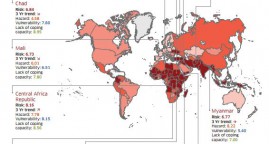
Index for risk management: results 2015
November 2014. INFORM is a global, open-source risk assessment for humanitarian crises and disasters. It can support decisions about prevention, preparedness and response.
